Google Earth (.kmz) 导出
KML 是 Google Earth 与 Google Maps 使用,含有地理数据的模型文件格式。
To save as or export a Rhino model
- On the File menu, click Export Selected or Save As.
- In the dialog box, the Files of type list displays the currently supported file types for export.
- In the Files of type box, select the supported file type.
- In the File name box, select or type a file name.
- Specify what is to be saved.
- If the export can be configured, click the button to specify export settings.
- Mesh file types export NURBS surfaces as meshes either with the specified meshing options, or the document render mesh settings.
| Options (For Rhino 3DM only) | |
|---|---|
|
Save small |
Though clearing the render meshes makes the file smaller, it will shade and render more slowly the next time you open the file. |
|
Save geometry only |
Saves geometry objects only. No layers, materials, properties, notes, or units settings are saved. This is similar to exporting the objects. A new file is made, but it does not become your active Rhino model. |
|
Save textures |
Embeds external textures used by materials, environments and decals into the model. |
| Save plugin data | Saves data attached to objects or the document by plug-in applications. |
附注
- Google Earth .kmz 可以像其它网页常用的格式 (.html、.jpg、.gif...) 一样经由网站发布,但网站主机必需要有处理 .kmz 文件的功能。
- 使用 EarthAnchorPoint 指定模型在地球上的位置点。
- 模型必需使用建筑使用的单位,例如米。
- 设定 Perspective 视图摄影机的镜头长度为 21 毫米,符合 Google Earth 的摄影机视野角度。
- 储存 Google Earth 文件时请确定您在 Perspective 工作视窗中是从地平面以上观看要导出的物件。
- 以 Mesh 指令将复杂的曲面物件转换为网格时模型的数据量会很多,请尽量减少网格面的数量。
- 材质的颜色是模型在 Google Earth 里的显示颜色。
- 您可以使用 Google Earth 打开、编辑、储存 .kmz 文件,加入非 3D 几何图形的数据。
请参考
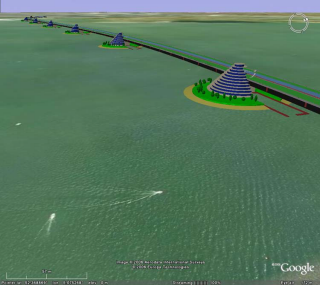
使用 Rhino 为 Google Earth 创建一座桥的三维模型